WeatherRouting
Back in the day when 20 knots was considered blazing, a comfortable day’s run was perhaps 100 or 120 miles and trips over 200 miles were rare. Today, 200-mile “day hops” and 1,000-mile delivery passages are not uncommon. This newfound freedom, though, comes at a price. While conditions may be ideal at the beginning of a voyage, things can be very different hundreds of miles away; yet traditional sources for weather information-TV or VHF-only cover a small and localized area. The result: Yachtsmen may outrun their local weather forecast before lunch.
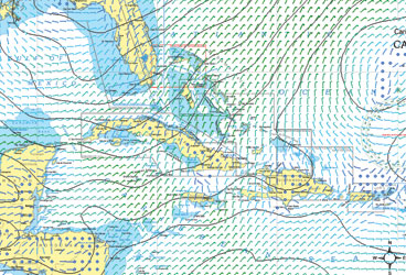
Fortunately, new communications options have kept pace with improved boat and engine technology. The Internet provides worldwide weather information with just a few mouse clicks; in seconds I can acquire the forecast from my dock in Miami all the way up the coast to Norfolk or down to Cancun. The options, though, are not all alike, so it’s best to have more than one source.
NOAA’s National Data Buoy Center, for instance, gives present wind, sea and atmospheric conditions at hundreds of coastal monitoring stations and offshore weather buoys. Each station’s Web page displays an hourly report of conditions over the previous 24 hours, and provides links to regional wind maps and text versions of NOAA’s weather radio broadcasts.
For upper level winds, surface wind and wave forecasts, or satellite images, NOAA’s National Weather Service Marine Forecasts page holds dozens of links. Tide predictions are made for times of high and low water, and every half hour throughout the day. Another link shows present water levels, which are often different from tide predictions.
Ease of interpreting data is a major factor in your choice of sources. Reading buoys takes experience, satellite images and synopsis maps require interpretation, and Internet sources assume a certain degree of computer savvy. Then again, text forecasts on the Web are certainly convenient but rather generic, forecasting an area perhaps 50 miles square over a 12-hour period near shore, and are even less specific offshore.
Even if the technology front has passed you by, help is just a phone call away. For a surprisingly small fee, yachtsmen can have their own on-call meteorologist, providing custom-tailored information for a specific vessel, route and time. Weather Routing, based in upstate New York, was founded over 40 years ago to provide merchant ships with favorable routes to save fuel and avoid harming cargo.
Sailors are often the first consumers to benefit from technological advances. While sailboats, trawlers and the increasingly popular expedition yachts don’t cover vast distances in a day, they often stay at sea for long periods, requiring accurate weather information while offshore. Communications advances provide Internet access through cellular phones, satellite, and even HAM and SSB radios. The National Weather Service Marine Forecasts Web page mentioned earlier has the most extensive, up-to-date information I’ve found on offshore access to the Web, with dozens of links to service providers. The site also lists sources for foreign marine forecasts and the U.S. Navy’s worldwide weather information.
Given their slow speed, trawlers and sailboats are also particularly concerned with ocean currents; bucking a knot-and-a-quarter current at 7 knots is hell.
There are several sources for ocean current information free on the Web or through private services. Rutgers University provides NOAA satellite data of the Gulf Stream online, although reading these charts takes a skilled eye. Jenifer Clark, who’s studied ocean currents for NOAA for 26 years, interprets satellite images and sells her Gulf Stream charts to navigators. Fishermen, another group who have always sought the most modern technology, use satellite information to locate rapid changes in ocean temperature that often hold fish. Dr. Mitchell Roffer’s famous ROFFS Report shows fisherman the likely hot spots for a fee. Roffer also uses NASA’s latest ocean color imagery, factoring in water clarity and plankton density.
Below is a list of resources to help you prepare for the weather:
Best Weather Sites:
ROFFS-Roffer’s Ocean Fishing Forecasting Service Inc., Jenifer Clark’s Gulfstream, Weather Routing Inc., Wilkens Weather Technologies, The Weather Channel Marine, SkyMate, Commander’s Weather, Meteo France.
Government Websites:
NOAA Marine Forecasts home page, NOAA National Data Buoy Center, NOAA National Hurricane Center, NOAA Geostationary Satellite images.
University Websites:
Rutgers University Coastal Ocean Observation Lab, University of Miami Rosenstiel School of Marine and Atmospheric Science, University of California, Santa Barbara Indterdisciplinary Oceanography Group.
For-Profit or Subscription Websites:
Weather Underground, Weather Flow, Sail Flow, Fish Weather, iWindsurf.
Routing Software:
Expedition, Adrena Tactique, Deckman.


