Mastering Marine Electronics
Let’s face it: Most of us are surrounded by technology that far exceeds our technical proficiency. For example, how many of us really use our PCs to their full potential? For plenty of yachtsmen, this also holds true for their electronics. After all, modern electronics suites can generate far more information than any brain — even one that’s fully dedicated — can digest. As a result, most skippers learn the basics, leaving many useful functions unused. Here are five commonly underutilized features and a look at how they can improve your on-the-water experience.
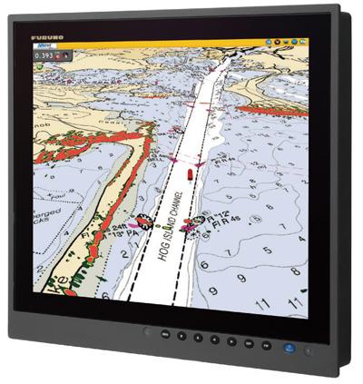
3-D Radar. Dubbed the “most highly advertised, least-used feature” currently on the marine-electronics market, 3-D radar offers a fantastic perspective on your surroundings. While the marketing name is a misnomer (actual “3-D radar” doesn’t exist), several manufacturers incorporate a graphics-overlay application that blends satellite photos and charts into a multidimensional image, much like the “Street View” function on Google Earth. “3-D radar is a perspective view of the radar picture,” said Peter Prowant, Furuno’s Southeast regional manager. “It’s like a heads-up display. Buoys and vessels appear to float on the surface level.” Interestingly, how each manufacturer presents this view differs substantially. For example, Furuno’s NavNet 3D offers a full-time 3-D perspective, whereas Simrad and B&G use TurboView technology that allows a user to choose between a 2- or 3-D perspective.
Multidimensional graphics rendering provides an amazingly interactive way of engaging the available information, and of considering your spatial relationship with other boats and hazardous objects. Once mastered, 3-D radar’s heads-up view is extremely useful for piloting, especially when you’re cruising near a shoreline or negotiating a busy channel, and the amount of easily digestible information — all presented in a neat graphics package — far exceeds anything previously available for boaters.
Multiple Windows. High-resolution monitors and multifunction displays (MFDs) are spectacular at presenting information in full, rich color. While most users simply toggle between applications (such as radar, fish finder and chart plotter), most modern MFDs can simultaneously present multiple windows, each showing a different application; most also allow you to build custom screens.
While the details of navigating to a split-screen view are brand/model specific, the basic premise involves using a special button (or tapping the screen) to select which applications you want to view simultaneously (applications can be viewed vertically or horizontally). One application is usually “live,” while the others are watch-only; a button or a tap allows you to transition between applications. Most units also readily allow you to jump from a split-screen view to a full-screen view.
Customized screens are another commonly underutilized feature. Here, you can customize which applications are visible on-screen, while still being able to toggle to full-page or split-screen views.
A cautionary note: Most MFDs can simultaneously run mulitple windows, potentially creating information overload. Avoid this by picking your favorite few applications — you can always scroll through to other functions.
A-Scope Feature on Fish Finders. A lot of boaters carry a fish finder as a means of scoping out fish and gathering depth and contour information. Fish finders sending and receiving dual frequencies as high-frequency waves (generally 200 kHz) present a high-quality but narrow-radius view of what’s below the transducer, and low-frequency waves (typically 28 kHz to 82 kHz) produce lower-quality results over a wider swath of bottom and can also detect fish at greater depths. Alter frequencies, and both the area and the quality of the information that you’re looking at change.
All information is processed and plotted on an X/Y graph that’s presented onscreen, with the graph’s X-axis being time and the Y-axis representing the tallest points on the ocean’s floor. But because information is being processed, there’s a slight lag between what you’re passing over and what’s on-screen. With a fish finder’s A-scope feature, however, a real-time view of what’s below the transducer is also presented. As the fish finder writes new information on the graph, a split-screen field of vision presents a real-time view of sonar returns — expanded horizontally — in a series of constantly updating snapshots, as well as the standard X/Y graph. Some A-scope presentations also use the particular beam-width of the frequency and transducer in use, and the depth, to calculate the width of bottom being imaged, which is a great way to learn about a fish finder.
ARPA and MARPA. While the Automatic Identification System (AIS) is brilliant at displaying the course and speed of other vessels, your radar potentially has a different kind of built-in collision-avoidance feature. An Automatic Radar Plotting Aid (ARPA) acquires radar targets once they enter a defined guard zone, whereas Mini Automatic Radar Plotting Aid (MARPA) allows a user to select one or more targets manually. Once acquired, ARPA and MARPA automatically track each target, generating information such as closest point of approach, time to closest point of approach, range, bearing, speed and course. They then categorize each target as “safe” or “dangerous” and sound an alarm if a target enters a predetermined safety perimeter; some models display a vector indicating the target’s direction of travel.
To calculate this information, the radar requires real-time speed and course information from a GPS and usually from a high-speed heading sensor, in addition to a well-defined target. Given these complexities, ARPA/MARPA numbers are not as accurate as AIS information: While your MFD can plot precise AIS GPS reports, it’s likely using vaguer information for each radar target. The best option, of course, is to use both ARPA/MARPA and AIS together for maximum situational awareness.
MMSI Numbers. The most important recent innovations in electronic safety equipment have been Digital Selective Calling (DSC)-enabled VHF and Class B AIS. In both cases, your boat’s Maritime Mobile Service Identity (MMSI) — a nine-digit identification number that’s unique to your vessel — is integral for this technology to work. MMSI numbers are sent in digital form over the two AIS channels to identify ships (AIS), and they are also used over regular VHF channels to let vessels call each other directly to discuss a converging-course situation, for instance, where AIS and DSC meet, or to call all nearby vessels automatically during emergencies (DSC).
Given the importance of MMSI numbers, you’d think all boaters would get one. Not so. Because the U.S. Coast Guard couldn’t reliably receive automated distress calls until recently, and also because many early DSC VHFs couldn’t reliably catch DSC calls, an attitude of apathy developed within the boating community. This attitude is changing: The Coast Guard can now receive automated calls, and what’s known as Class D DSC, which includes a dedicated receiver, is now required on all new VHFs sold in the United States. To get your MMSI number, log onto BoatU.S.’s dedicated MMSI page at www.boatus.com/mmsi.


