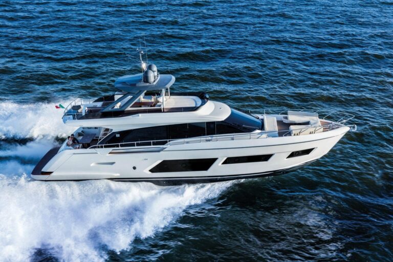
It was 0100 on the tennessee-tombigbee waterway, and Capt. Scott “Red” Flowers was running his Canyon Bay 28h at 17 knots. He encountered a tugboat pushing barges. The tug was illuminated, but the barges were dark. While Flowers is a self-described “old-school radar guy,” the situation was confusing and unfurling fast. Then his Tocaro Blue Proteus Hub prompted him with collision-avoidance alerts. “I hate to admit it,” he says, “but without Proteus, I may have gotten into the barges.”
Instead of crashing, Flowers completed his Great Loop Challenge route in 19 days, 19 hours and 50 minutes, besting the record by nine days while raising $1 million for the National Pediatric Cancer Foundation.
Radar is one of the most important collision-avoidance sensors afloat, but reading radar imagery is an art that can take years to master. It can be frustrating for boaters who only get out on the water a handful of times a season. Tocaro Blue’s Proteus Hub navigation system uses AI machine learning to demystify radar. It bolsters situational awareness by way of built-in cartography and networked automatic identification system data, creating user-friendly two- and three-dimensional screen views of the water ahead on compatible multi- function displays.
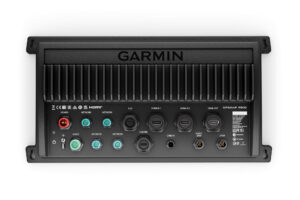
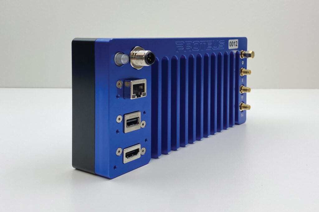
Tocaro Blue’s Proteus Hub ($2,950) is a black-box system that networks with a yacht’s NMEA 2000 backbone, also letting it access the boat’s AIS, compass (ideally, its satellite compass), depth transducer and GPS (or GNSS) sensor data. Proteus then connects with the MFD via Ethernet to access data from a compatible magnetron or solid- state radar and to display its 2D and 3D screen views.
Read More: New Yacht Tech for a New Season
Proteus Hubs are built from aluminum and Delrin plastic. They measure 8-by-4-by-1.5 inches. They sport 4G LTE, Bluetooth and Wi-Fi antennas and connectivity, along with N2K, HDMI, USB and Ethernet ports. They also come loaded with National Oceanic and Atmospheric Administration charts, and with bathymetric data sourced from Tocaro Blue’s user community. C-Map cartography is optional.
Proteus Hubs contain a central processing unit that runs Tocaro Blue’s machine-learning software, which “learns”—sans human instruction or programming—by applying algorithms and statistical models to networked data. Tocaro Blue also offers a software developer kit called Proteus Core that allows using the machine-learning software aboard third-party hardware.
“The intent with Proteus is to provide clear, smart navigation to the captain,” says Andrew Rains, Tocaro Blue’s senior sales director. “By that, we mean reducing the complexity of existing nautical charts and radar displays, and combining a lot of sensor information into one simple interface.”
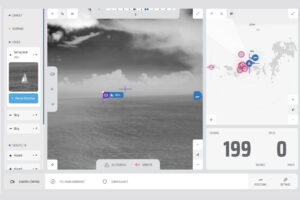
In the case of radar, Tocaro Blue’s auto-focus function uses machine learning to eliminate irrelevant radar returns, such as land and wave noise. It classifies returns into one of eight categories: land, shoreline constructions, bridges, wake, aids to navigation, small boats (less than 40 feet), medium-size vessels (40 to 150 feet) and large vessels (larger than 150 feet). All of them are represented graphically by icons.
“We can draw a picture of a real object instead of just a radar blob on the screen,” Rains says, noting that Proteus Hubs can classify and track an unlimited number of targets. “That lets us present a lot of information in a simplified format.”
The auto-focus function also helps the system predict how radar targets will behave, and it provides corresponding alert levels. For example, Rains says, small boats tend to exhibit more erratic behavior than large ships. Tocaro Blue’s machine-learning software uses its classification system, embedded cartography, and data coming from other networked sensors to predict the future behavior of its own vessel and of acquired targets over a 30-second horizon.
If this sounds like signal filtering on steroids, welcome to the AI age.
“Machine learning is a lot more sophisticated than filtering, but I’d say that we can intelligently filter [radar targets] because we use machine learning,” Rains says. Raw radar data, he adds, is better for the system’s machine-learning software than post-processed radar returns such as Doppler processing. “Machine learning gets better with the better data that you feed it.”
For example, if the system knows that some returns are land or aids to navigation based on its cartography, then its machine learning can focus on identifying the other targets and predicting their behavior.
This information, plus closest-point-of-approach data to all targets, is presented on a graphically intuitive 2D or 3D screen view on the networked MFD. Users can split their MFD screen between a Proteus Hub screen view and standard radar imagery.
The result, Rains says, is far greater situational awareness than bloblike radar returns, especially when tricky navigation or dodgy crossings are involved.
“It eliminates the question: What’s that?” Rains says. “It eliminates the time that they need to spend learning how to use all their radar capabilities.”
More-advanced users get the most value from the system, he adds, because the software “can present really intelligent collision-avoidance alerts to the captain.” Even old salts, of course, can get distracted.
Looking ahead, Tocaro Blue’s future appears equally clear. Recent years have seen the rise of optical-based collision-avoidance systems, and Rains says the Proteus Core software could complement this technology by residing on third-party hardware. In time, Tocaro Blue’s machine-learning software could also help demystify other instrumentation—say, forward-looking sonar returns. However, Rains says, this isn’t on the company’s immediate road map.
Tocaro Blue’s machine-learning software can also ferret out errors in networked sensors. For example, most autopilots are only accurate to a few degrees unless a satellite compass is involved. (This inherent error can be compounded by the presence of ferrous metals within ships and bridges.) Rains says Tocaro Blue’s machine-learning software can perform a “constellation lock” and triangulate on known reference points, using cartographic and radar data to correct for sensor biases.
While there’s currently no feedback loop to the erroneous native sensors, in time, Rains says, this information could make autopilots and other networked sensors more accurate.
So, for skippers who find radar confusing or want to increase situational awareness, Proteus Hub is worth investigating. Just ask Red Flowers. Despite holding his captain’s license for 45 years, his night on the Tennessee-Tombigbee Waterway could have ended differently without Tocaro Blue’s technology.
Busting Loose
For now, Proteus is available to boaters as a black-box system that networks with a vessel’s N2K and Ethernet networks to access radar and instrumentation data. Tocaro Blue may move to a software-as-a-service model and sell Proteus Core to boaters as software that runs aboard a personal computer or multifunction display.