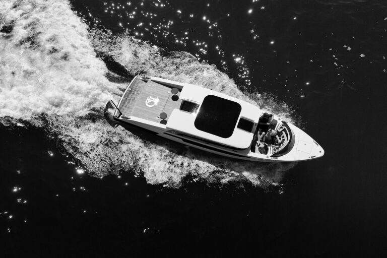
On September 7, 2018, the 170-foot steel-hull Ice Angel was cruising the waters of Prince Christian Sound off Greenland’s southern coast. Its speed was 14.5 knots when it struck an uncharted underwater rock. The yacht’s four guests and 15 crew were safe, but the yacht sustained significant damage, leaking oil into the pristine waters.
If the available hydrographic information—Greenland Chart 1103—had detailed this feature, the accident likely never would have happened. But believe it or not, Chart 1103 was made in 1927. It is considered to be of “reconnaissance nature,” meaning that its white areas—those without detailed soundings—cannot be trusted for safe passage.
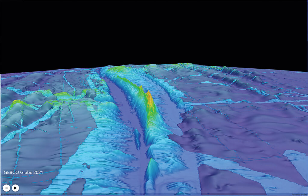
Unfortunately, Chart 1103 isn’t unique. Humanity has piloted unmanned vehicles on Mars, but we’ve only mapped about a quarter of the world’s seafloor. The Nippon Foundation-GEBCO Seabed 2030 Project, with help from international partners, aims to change this via community-generated bathymetric data. The partners range from government agencies (including official hydrographic offices) to nongovernmental and nonprofit organizations, and universities. They also include private companies such as FarSounder, the Rhode Island-based manufacturer of 3D forward-looking sonar.
Seabed 2030 was founded in 2017 as a collaboration between The Nippon Foundation, a Tokyo-based international nonprofit organization, and GEBCO (that’s General Bathymetric Chart of the Oceans), a joint program of the International Hydrographic Organization and the United Nations Educational, Scientific and Cultural Organization’s Intergovernmental Oceanographic Commission.
Back then, just 6 percent of the world’s oceans had been mapped to what Seabed 2030 terms “adequate” resolution. Seven years on, this metric approaches 25 percent.
“The primary mission is to deliver the first global map of the entire seafloor,” says Jamie McMichael-Phillips, Seabed 2030’s project director. He says that in some cases, this new data is replacing soundings that were collected using lead lines and sextants. “Without accurate maps of the global seabed, a full understanding of the ocean’s physical, biogeochemical and geological parameters is impossible to achieve.”
Seabed 2030’s 3D gridded bathymetric maps will help to further scientific understanding of complex natural processes, including ocean circulation and sediment transportation. The maps and data will also enable better weather forecasts, and more accurate climate models and tsunami warnings.
“Tsunami height is strongly determined by the shape of the seafloor in the run-up to landfall,” McMichael-Phillips says.
Seabed 2030’s map also promises to help businesses in areas such as natural-resources management (say, fisheries) and transoceanic communications and pipelines.
“Seabed 2030 receives generous donations of data from a growing global community of seafarers, nation-states, industry, academic researchers, philanthropic explorers and volunteers,” McMichael-Phillips says. He adds that while most bathymetric data is derived from sonar logs, Seabed 2030 accepts data collected via aircraft, unmanned vessels and satellites.
Anyone can contribute data, but Seabed 2030 maintains a group of partners—including FarSounder—that share a higher level of trust. Matthew Zimmerman, FarSounder’s CEO, says the company has been contributing bathymetric data to the International Hydrographic Organization since 2018 and became a Seabed 2030 partner last fall.
“I’m not a scientist. I’m an engineer,” he says. “I really like being able to enable science with the tools that my team and I develop.”
While any echo sounder can measure distance, not all information is created equally, he adds: “The sensor isn’t the problem, but the metadata is. It’s really hard to make charting decisions based on poor metadata.”
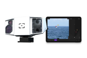
FarSounder documents the exact locations to within a few centimeters of a forward-looking sonar transducer, a third-party echo-sounder transducer, and GPS antenna(s) of every vessel where FarSounder equipment is installed.
“The metadata quality of our contributions is far superior to most crowdsourced contributions,” Zimmerman says.
In addition to becoming a Seabed 2030 partner, FarSounder recently won a Phase I Small Business Innovation Research grant from the National Oceanic and Atmospheric Administration. FarSounder is using these funds to create a cloud-sharing service for sharing anonymous bathymetric data (read: depth at a location in time) from participating FarSounder customers with Seabed 2030. If the data meets the project’s technical requirements and needs, Seabed 2030 can stitch it into the GEBCO world map.
Notably, Seabed 2030’s definition of “adequate” bathymetric resolution hinges on water depth. For depths down to 4,921 feet, Seabed 2030 aims for “100-meter resolution,” meaning at least one sounding in an area that measures 328-by-328 feet. For depths from 4,921 feet to 9,843 feet, this will be 200-meter resolution; for the nearly 73 percent of the seafloor that measures between 9,843 and 18,865 feet down, resolution requirements dip to 400-meter resolution. And for the deepest soundings—say, the 2.7 percent of the seafloor between 18,865 and 36,090 feet—the metric drops to 800-meter resolution.
It’s also important to understand that Seabed 2030 is creating a macro-level seafloor map, not cartography.
“One-hundred-meter resolution isn’t that helpful from a navigational point of view,” Zimmerman says. “It’s certainly helpful for understanding our world from a global science point of view, but it’s not navigation-quality information.”
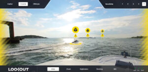
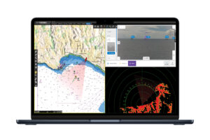
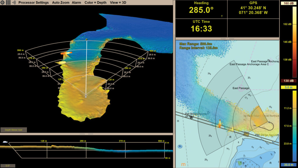
FarSounder’s systems provide real-time sonar imagery forward of a vessel’s bow. They also build and store a high-resolution bathymetry map of everywhere the vessel has sailed. This local history map resides on the vessel’s FarSounder bridge computer, but it can be shared anonymously with the FarSounder community via the company’s optional fleet-sharing program whenever connectivity exists.
This is where things get interesting for participating FarSounder customers who opt in. “We needed to find a way to motivate our users to contribute, as well as being able to pass this on to the [Seabed 2030] community,” Zimmerman says. The solution was to create two classes of data for customers who opt into the company’s fleet-sharing program.
“Our customers get the full-resolution data as part of the service, but we’re contributing a slightly lower-resolution data [to Seabed 2030],” Zimmerman says. “The high-res maps from the FarSounder sonar, the highest resolution, that’s staying just with the FarSounder customers who are part of this fleet-sharing service.”
Given that FarSounder customers often buy this equipment to ply seldom-seen waters, participation confers membership into a kind of sonic explorers club. “We have pretty good coverage in areas that don’t have good chart data,” Zimmerman says. “We really want to encourage our customers to contribute so that they can also reap the benefit.”
FarSounder might someday monetize this data, but this isn’t the current model. “FarSounder is in the business of selling sonars,” Zimmerman says. “We’re in a unique position where we can participate, we can make contributions, and we don’t need to worry about supporting our company financially through the data transactions because we do that through our hardware sales.”
The net result is a win-win-win: Seabed 2030 receives high-quality data from a trusted partner, the general public and scientific community benefit from the free and downloadable GEBCO world map, and participating FarSounder customers get higher-resolution data.
Still, scale and time emerge as question marks.
“Even with everybody doing all of the mapping they possibly could, we’re not going to meet the Seabed 2030 goals of mapping the world’s oceans, certainly not by 2030, likely not even in the next 70 years,” Zimmerman says.
Seabed 2030’s team acknowledges this, but with a caveat: “A combination of a large fleet of conventionally crewed vessels and robot boats in larger numbers would be a game-changer,” McMichael-Phillips says.
In the meantime, Seabed 2030 is already providing the world with higher-resolution, large-scale seafloor bathymetric data than has ever existed. As for Chart 1103, Seabed 2030 will eventually help fill in the white areas. Cruisers everywhere are encouraged to consider joining FarSounder’s participating community.
Seafloor Scans
FarSounder’s Expedition Sourced Ocean Data Collection Program provides external USB drives that collect raw sonar data. This project requires significant back-end processing work for FarSounder. It’s run on an invitation-only basis, based on sailing itineraries. This high-quality data contributes to FarSounder’s fleet-sharing program.