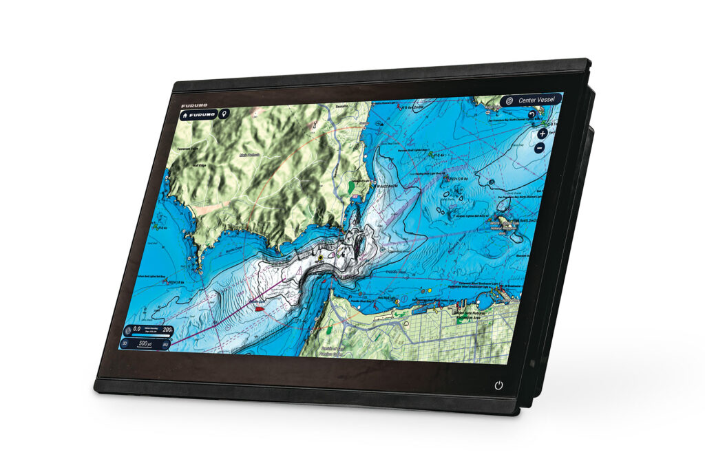
I’m a cartography geek. I can invest hours studying charts of enticing coastlines or yawning offshore canyons. So, you can imagine my reaction when I checked out TimeZero’s TZ Maps displayed on Furuno’s new TZtouchXL multifunction displays. The image quality and customizable color palettes are outstanding. TimeZero’s bathymetric data pairs with Furuno’s newest chart engine to enable Furuno’s AI Routing, which generates safe routes based on a vessel’s parameters and TZ Maps’ embedded data.
But this just dings the gelcoat when it comes to the capabilities of the TZtouchXL family. While Furuno has long built multifunction displays, previous generations of TZtouch MFDs needed more screen real estate. Today’s versions deliver better imagery, faster processors and improved RAM.
Most importantly, TZtouchXL displays are the only MFDs that can render TimeZero’s TZ Maps. Furuno owns a 49 percent stake in TimeZero, and the two companies collaborate.
TZtouchXL MFDs come in 10- ($3,000), 13- ($4,000), 16- ($5,900), 22- ($10,500) and 24-inch ($12,000) screen sizes, and have 1920-by-1080 high-definition screens, which highlight TZ Maps’ rich colors and bathymetric details. All five MFDs also have in-plane switching, which brightens the displays for readability in direct sunlight and from many viewing angles. The 10- and 13-inch MFDs sport hybrid user interfaces, while the 16-, 22- and 24-inch displays are touchscreen-only.
According to Matt Wood, Furuno’s national sales manager, the three larger TZtouchXLs have smaller bezels than their predecessors. This change allows for more glass in a comparable box and lets owners create all-glass bridges.
TZtouchXL MFDs are powered by hexacore processors, with extra computational overhead. “There are six primary central processing units doing the navigation processing, plus two processors dedicated to video presentation,” Wood says. “So there are eight processors total, with some shared responsibility for six of them.” This combination lets the MFDs display TZ Maps. “Speed and RAM have also been improved,” he adds.
While the three smaller TZtouchXL displays come with embedded fish finders and side-scanning sonars, the 22- and 24-inch displays also work with Furuno’s networked sonars. Likewise, the three smaller displays come with internal GPS receivers, while the bigger MFDs work with external GPS (or GNSS) receivers. All five MFDs play nicely with Furuno’s satellite compasses and digital radars, the latter unlocking some of the displays’ finest features.
TZ Maps are visually engaging and data-rich. “TimeZero’s MaxSea group is a reseller for every hydrographic office,” Wood says. “TZ Maps are based on HO data that’s amplified and augmented with private data and with bathymetric lidar. Users can add community edits and points of interest to their TZ Maps, but users’ depth measurements aren’t included in TimeZero’s data sets.”
Currently, TZ Maps cover Australia, Europe and North America, with global coverage in the works. They can be viewed across all networked displays. TZtouchXLs come with a one-year TZ Maps subscription.
Anglers can use this tech to access Furuno’s Dynamic Fishing Maps with five different resolution levels, including hybrid satellite and contour charts, and 3-inch contour lines. BathyVision lets anglers adjust onscreen terrain shading to highlight undersea structure and contours.
All kinds of boaters can use Furuno’s AI Routing to simplify navigation. Users select start and end points, and the MFDs interrogate the chart’s bathymetric data to generate safe, vessel-specific courses. Users can edit these routes and add waypoints.
Incorporating Furuno DRS-NXT radars can unlock two important safety features. First is Risk Visualizer, which color-codes targets based on their threat level and depicts areas that pose high risk. This provides quick information and ETAs to dangerous waters.
Second is Furuno’s AI Avoidance feature, which calculates the safest routing around dangerous targets. This removes radar guesswork, especially for yachts in busy shipping lanes or hectic harbors. “It’s not dead reckoning,” Wood says. “It’s taking dynamic [radar] data into account.”
This is also where Furuno’s hexacore processors come into play, as AI tools require fast math. “We’re allowing the processors to do work that we weren’t letting them do before,” Wood says, noting that the intention is to help navigators make safe decisions. “The sky is the limit for TZtouchXLs.”
For yacht owners who want glass bigger than 24 inches, Furuno builds black-box marine processors that can drive 70-inch displays. The company has yet to introduce a TZtouchXL black box, but Wood says this is coming.
All products have their pros and cons, and TZtouchXLs are no exception. Pros include simplified installation, competitive pricing, and software for European and North American markets. Cons include the fact that AI Routing doesn’t consider weather (GRIB files) when creating routes. To solve that problem, Wood says users can add a separate Furuno BBWX4 ($500) to access SiriusXM Marine weather, and access free worldwide forecasts through Furuno’s NavCenter Weather feature.
A word of warning based on my experience: It’s easy to invest significant parcels of time being mesmerized by TZ Maps. But, given the importance of safe navigation—and for anglers, of finding fish—there could be strong returns on this investment.
Interface Options
If you cruise on lumpy seas, Furuno’s MCU006 and MCU006H (each $450) remote controls add to the TZtouchXL’s touchscreen interface. These hardwired remotes use beveled buttons and rotary knobs. The MCU006 is oriented vertically, while the MCU006H accommodates horizontal installation spaces.


