ytgdec4blog
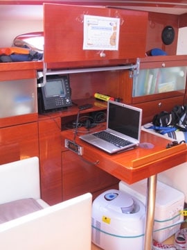
16°08.276N 48°53.786W Boat Speed: 5.5 Knots Wind Speed: 10-14 knots Magnetic Direction: 253° Distance Traveled Thus Far: 2,059.4 nautical For the last few days, we have been on a west/southwest course and the wind has dropped off to around 10-15 knots. We’ve managed to keep a good point of sail, and with the forecast telling us that the wind will shift in a few days and come from the south, our current course will set us up for a tack and a good point of sail giving us, we hope, good speed for our last day or two we approach St. Lucia. We have a few ways of plotting our course aboard Snark. Topside, in the center of the two helm stations, we have a Simrad DS44 chartplotter, linked to a Simrad CX34 chartplotter down below in our nav-station. We have wind chart downloads from the World Cruising Club that we read every day, sometimes several times a day, to help us choose the best course. When you’re on the ocean, the difference of 30 or so miles north or south could mean the difference between slack winds and healthy gusts. For instance, on Thanksgiving, we were moving along at a healthy 7.5-8 knots, with 15-20 knots of boat speed and a good point of sail. Meanwhile, 50 miles to our north, a fellow ARC boat was crawling along at 4-5 knots of boat speed, with single digit wind speed. We also have, of course, a large paper chart of the North Atlantic Ocean. We plot our position and course on the paper chart, so we can see at a glance where we’ve been and how far we have left. And the distance between where we are and St. Lucia is gets smaller every day.

